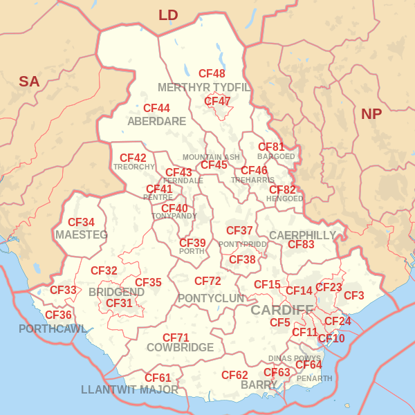
Cardiff Leaflet Delivery Postcode Map
Total Cardiff & surrounding area households
Total Cardiff and surrounding area population

| Postcodes | Areas | Households | Population |
|---|---|---|---|
| CF3 | CARDIFF SOUTH (East): | 16,081 | 40,421 |
| CF5 | CARDIFF WEST (South): | 26,246 | 62,960 |
| CF10 | CARDIFF CENTRAL / CARDIFF SOUTH: | 2,695 | 6,061 |
| CF11 | CARDIFF CENTRAL / CARDIFF SOUTH: | 12,364 | 28,676 |
| CF14 | CARDIFF NORTH (West): | 29, 045 | 72,616 |
| CF15 | CARDIFF WEST (North): | 6,442 | 16,363 |
| CF23 | CARDIFF NORTH (East): | 16,583 | 42,470 |
| CF24 | CARDIFF CENTRAL: | 18,462 | 46,805 |
| CF31 | BRIDGEND TOWN, Brackla, Coity, Pen-y-Fai | 16,035 | 38,444 |
| CF32 | BRIDGEND: | 11,920 | 29,003 |
| CF33 | Cornelly, Pyle | 5,514 | 13,436 |
| CF34 | MAESTEG TOWN, Llangynwyd, Caerau, Nantyffyllon | 8,557 | 20,680 |
| CF35 | BRIDGEND: | 5,630 | 14,540 |
| CF36 | PORTHCAWL TOWN, Nottage, Newton | 6,873 | 15,721 |
| CF37 | Pontypridd Community: | 15,680 | 39,071 |
| CF38 | Llantwit Fardre Community: | 8,526 | 21,905 |
| CF39 | PORTH Rhondda Area (RCT): | 11,319 | 28,020 |
| CF40 | TONYPANDY Rhondda Area: | 8,513 | 20,938 |
| CF41 | PENTRE Rhondda Area: | 4,657 | 11,341 |
| CF42 | TREORCHY Rhondda Area: | 5,926 | 14,106 |
| CF43 | FERNDALE Rhondda Area: | 5,306 | 12,578 |
| CF44 | ABERDARE Cynon Area: | 16,271 | 39,048 |
| CF45 | MOUNTAIN ASH Cynon Area: | 8,093 | 19,743 |
| CF46 | TREHARRIS MERTHYR TYDFIL: | 5,760 | 14,230 |
| CF47 | MERTHYR TYDFIL TOWN, Gurnos, Penydarren | 8,504 | 20,389 |
| CF48 | Cyfarthfa, Pant, Merthyr Vale, Troed-y-rhiw, Vaynor, Pentrebach | 10,784 | 25,970 |
| CF61 | LLANTWIT MAJOR TOWN, Llan-maes | 3,956 | 10,133 |
| CF62 | BARRY TOWN (part of), Rhoose, St Athan, Llancarfan, Barry Island | 15,698 | 38,935 |
| CF63 | BARRY TOWN (part of), Cadoxton, Barry Docks | 7,806 | 18,779 |
| CF64 | PENARTH TOWN, Dinas Powys, Sully, Llandough | 14,508 | 34,418 |
| CF71 | COWBRIDGE TOWN, St Brides Major, Welsh St Donats, Pendoylan, Llandow, Colwinston, Llanblethian, Penllyn, Llanfair | 3,630 | 9,000 |
| CF72 | PONTYCLUN Taff-Ely Area: | 9,144 | 22,577 |
| CF81 | BARGOED TOWN, Aberbargoed, Darran Valley, Gilfach, Pontlottyn | 6,727 | 16,142 |
| CF82 | HENGOED, Cefn Hengoed, YSTRAD MYNACH TOWN, Gelligaer, Maesycwmmer | 7,685 | 18,235 |
| CF83 | CAERPHILLY TOWN, Abertridwr, Senghenydd, Bedwas, Trethomas, Machen, Llanbradach, Pwllypant, Penyrheol, Energlyn, Trecenydd, Rudry | 21, 291 | 52,744 |
Total Cardiff Households
Total Cardiff Population
Cardiff Only
| Postcodes | Areas | Households | Population |
|---|---|---|---|
| CF3 | CARDIFF SOUTH (East): | 16,081 | 42,421 |
| CF5 | CARDIFF WEST (South): | 26,246 | 66,021 |
| CF10 | CARDIFF CENTRAL / CARDIFF SOUTH: | 2,695 | 6,061 |
| CF11 | CARDIFF CENTRAL / CARDIFF SOUTH: | 12,364 | 28,676 |
| CF14 | CARDIFF NORTH (West): | 29,045 | 72,616 |
| CF15 | CARDIFF WEST (North): | 6,442 | 16,363 |
| CF23 | CARDIFF NORTH (East): | 16,583 | 42,470 |
| CF24 | CARDIFF CENTRAL: | 18,462 | 46,805 |
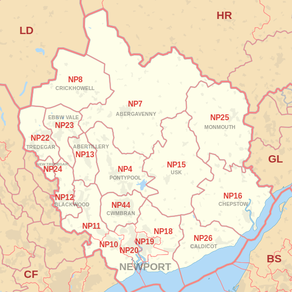
Newport Leaflet Delivery Postcode Map
Total Newport households covered
Total Newport population covered

| Postcodes | Areas | Households | Population |
|---|---|---|---|
| NP10 | Western Newport, including Bassaleg, Duffryn, Rogerstone | 7,809 | 18,913 |
| NP11 | North-western Newport, including: Abercarn, Crumlin, Cwmfelinfach, Risca, Ynysddu | 14,834 | 35,524 |
| NP12 | Blackwood, Pontllanfraith, Wyllie | 12,762 | 31,324 |
| NP18 | Eastern Newport, including Caerleon, Langstone, Llanwern, Nash, Llandegveth Underwood | 6,590 | 16,887 |
| NP19 | Eastern and East Central Newport, including: Beechwood, Maindee, St. Julians, Ringland | 20,331 | 49,824 |
| NP20 | Western and West Central Newport, including: City centre, Pill, Maesglas, Crindau, Malpas, Bettws | 20,978 | 49,056 |

